Monday, June 28, 2010

DAYS 64 FROM SOUTH TO NORTH - TOP END (NORTHERN TERRITORY) TRIP

27 June 2010

JASPER GORGE, BUCHANAN HIGHWAY – FLORA RIVER NATIONAL PARK

I am writing this listening to the very loud roar of the water nearby and the whistling sound of what I think is a kite even though it is late at night.


After exiting Humbert Station yesterday we followed the road to Buchanan Highway.


Although it was a dirt road it was a good road.


We found a beautiful campsite at a section of the road where it goes through Jasper Gorge.


It was a beautiful setting. Although the road was just above it, you couldn’t see it from the campsite and there was hardly any traffic along it.


In the morning the birds woke us.


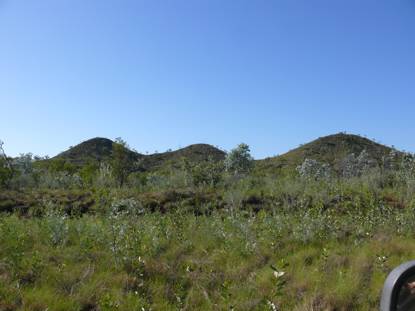
We travelled along the Majestic Jasper Gorge.


It looked just so grand.


We decided to go back to Timber Creek to buy a book for one of our sons and a present for the grand children. So at the intersection of Buchanan Highway and Victoria Highway we backtracked to Timber Creek to find the shop was closed. We had lost sight of what day of the week it was. It is Sunday and everything is closed. So we turned back and headed towards Katherine.


It never ceases to amaze me how different a road can look from each direction.


We see the mighty Victoria River for the last time as we go further east. Australia is an amazing country. Here in the north there is so much water but the land is so infertile. A very harsh and hard but beautiful environment in this corner of the country.


Mustering is well on the way here. We saw cattle in yards yesterday. Today we saw the stockmen on horses moving a herd.


We decided to go to Flora River National Park and we are so glad that we did come here. The road here was fabulous. It was like a highway even though it was a gravel road. The first 20km were smooth as anything. We were flying at 80km on this section. The next 20 km were not quite as fast as there were some corrugations on it but it was still very good.


We went to the Flora River first where there is a boat ramp.


Well there is always a first for everything. Crocodile safety warning signs are everywhere. They tell you to not step in the water at all at every bit of water access points. They even have a boat launching ramp with instructions on how to launch the boat and bring it in without going in the water. A winch at the top,


then a ramp with steps either side of it to lower the boat or pull it up. The same advice is for putting canoes in the water.


We then came back to the day car park and went on the two walks. This is a most amazing place. The Djarrung Falls are just spectacular. You can hear the water from a far.


It was not possible to take a photo of the full falls even by putting them into a panorama shot. There were several sections to the falls and they are very, very wide but due to the pandanus and monsoon jungle type of environment you could only see a section from any one spot.


We then went up to Kathleen Falls. Absolutely amazing. There were falls direction that you looked. The sound from the water cascading down was deafening. The sound was deafening.


At both of these falls the building up of Tafa walls and dams produce the walls over which the falls cascade. The water apparently cascades ove a series of these Tafa walls through the dry woodlands until it reaches the Kathleen River. In the dry season springs in the area keep feeding the river.


How amazing is nature at work!


At the campsite we set up and got on with the chores. The clothes needed washing and the solar panels needed cleaning.


In the surrounding trees there are interesting nests. Not sure what they are.


I think these are the green ant nests. One bit hubby today. So he took a bite of it as it is edible. He said it was quite nice.


There were quite a few green ants on a tree nearby.


The berries on this tree looked strange. I wandered whether they were a type of parasite as they seem to be sticking to the branches. They appear to be using the tree as a host- maybe I am wrong.


There appears to be a small spring nearby as there is constant water there whilst we have been here and in the heat – 32 today – it should have dried up in that time. Birds keep visiting it for a drink.


At dusk a wallaby visited the campsite.


Another amazing place. Another lovely day.  Tomorrow we go to Katherine to refuel and restock and then we are off to Gove Peninsula, Nhulunbuy.

DAYS 63 FROM SOUTH TO NORTH - TOP END (NORTHERN TERRITORY) TRIP

26 June 2010

GREGORY NATIONAL PARK – WICKHAM TRACK, MOUNT SANDFORD HUMBERT RIVER ROAD FROM FISH HOLE


We had to back track about 600 metres over the rocky creek bed and tricky corner and then go south about 300 metres to the Wickham track.


It is amazing how totally different the three tracks in the park are.


Hubby said to me that the track has not been used for a while once we were on it. It sure was in use today as three cars passed us going north. Apparently more people are coming out to explore this area.

 In places it was difficult to see the track ahead.

In places it was smooth in others a bit bumpy.


The scenery again was very different.


There were many creek crossings and water channel crossings. Hubby referred to this one as a hiccup to the smooth running track at the time.


Often the creek bed was quite dry


but on either side were lovely water pools.


After one creek crossing we were hit by a swarm of locusts. They continued with us for quite a while.


The jump up on the way up very interesting.


This time there was a real sense of going up to something.  The views from the top were spectacular. The so called tent hills in the distance were very striking.


On the way down needed low 2nd gear. It was a short distance down and very deceiving. Didn’t look bad but all advice was use low gear up or down on this stretch.


As we approached Wickham river we wandered whether we would make it as this branch was low and the question was whether we could dodge it or whether we would have to cut it. We just made it as there was a ditch in the track.


Wickham River was beautiful.


There were no boabs on this stretch of the road. Lots of different types of wattles were seen along this stretch of the track.


Some trees were really into doing a contortion act.


There were quite a few cattle around on this track. We didn’t know whether this one was going to charge us or go the other way. Lucky for us it turned and went away.


Most of the track was more forgiving on the car – not as strenuous. It was the first time we came across a sign indicating that we were going past ceremony country.


At a spot where we were expecting a track to the river we came across a sign indicating that beyond that point on the road to the right was a sacred site and no sign of the expected track was to be seen.


We knew we were out of the park when we saw fences appear.


At the end of the Wickham Track we turned left to go along the Mount Sandford Humbert River Road. Note how insignificant the track to the left looks.


This second part of trip towards Humbert Station was full of surprises.


First 11 kilometres very hard on the tyres as some of it was along a channel of the Wickham River over loose stones. At times it was about kilometre in length in other places less. I measured one section as being 600 metres. This part of the so called road was very daunting when you couldn’t see the end to it.


You felt as if you were driving in a gorge with the Wickham River just beyond the grasses and the escarpment rising on the other side. There was no opportunity to decide to go back as there was no way you could turn around.


There were quite a few creek crossings along the way.


We didn’t have any track notes for this and wondered what we were in for as we drove between long grasses and tall shrubs. In places the grasses nearly obscured the track. They were also quite tall – above the window in places and we do sit very high up compared to an average 4wd.


At times it was spot where the track is going.


Then about eleven kilometres in after a creek crossing to our surprise a graded road was in front of us. From then on it was generally smooth sailing.


The last creek crossing was wet black soil. Hubby got quite worried as he crossed it. He felt the back wheels begin to sink in. Luckily there was a rock base on exiting it.


Eight gates had to be opened and shut before reaching Buchanan Highway.


As we left through the last of Humbert Station gates there was a sense of relief that we had got through this part of the trip safely and with the car intact. None of the drawers or cupboards swung open through the rough tracks. Only the fridge had jumped around a bit in its lodgings.


The trip through Gregory National Park was absolutely awesome. A beautiful place. It sure has plenty of flies, termite mounds and birds. Each track had its own beauty and challenges. The Bullita Stock Route was the most difficult. The highlights here were the two East Baines River crossings and the limestone steps. The next in difficulty was the Humbert track. The highlight here was crossing the Humbert River. The Wickham track was the most picturesque. The highlight here was the jump up.

We will do it again if possible.